
Location

Located near the geographical and demographic center of the US, Northwest Arkansas provides the transportation infrastructure to access your suppliers and customers.

Surface Transportation

Interstate 49 – Provides north/south access for Northwest Arkansas and currently runs through western Arkansas from Kansas City, Missouri continuing on through the state of Louisiana. This interstate will eventually be a north/south connection from Canada to the Gulf Coast.

Interstate 40 – It’s the most continuous east/west interstate in the U.S. A 40-mile drive south from Fayetteville on I-49 provides direct access to it.

U.S. 412 – Connects Northwest Arkansas to Tulsa in the west.

Air Transportation

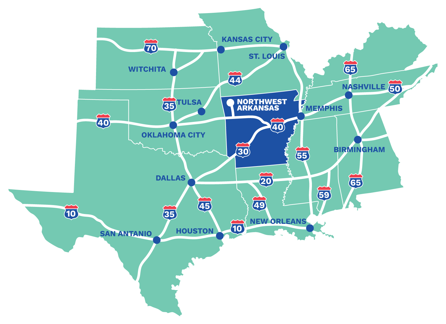
Northwest Arkansas Regional Airport (XNA) offers daily nonstop service to Atlanta, Charlotte, Chicago O’Hare, Dallas/Fort Worth, Denver, Houston, Los Angeles, Minneapolis/St. Paul, New York LaGuardia, Newark, Washington D.C. (Reagan National) and San Francisco. Additionally, Allegiant Air offers less-than-daily service to Las Vegas, Orlando, and Destin. Business travelers account for a high percentage of passengers using XNA. It’s the closest commercial airport for business people who want to reach the headquarters of Walmart Stores, Tyson Foods or J.B. Hunt Transport Services, and the airport’s services support the work of the 1,450 Walmart suppliers with operations in Northwest Arkansas. With about 45 outbound flights a day, airlines serving the airport are Allegiant Air, American, Delta, and United.

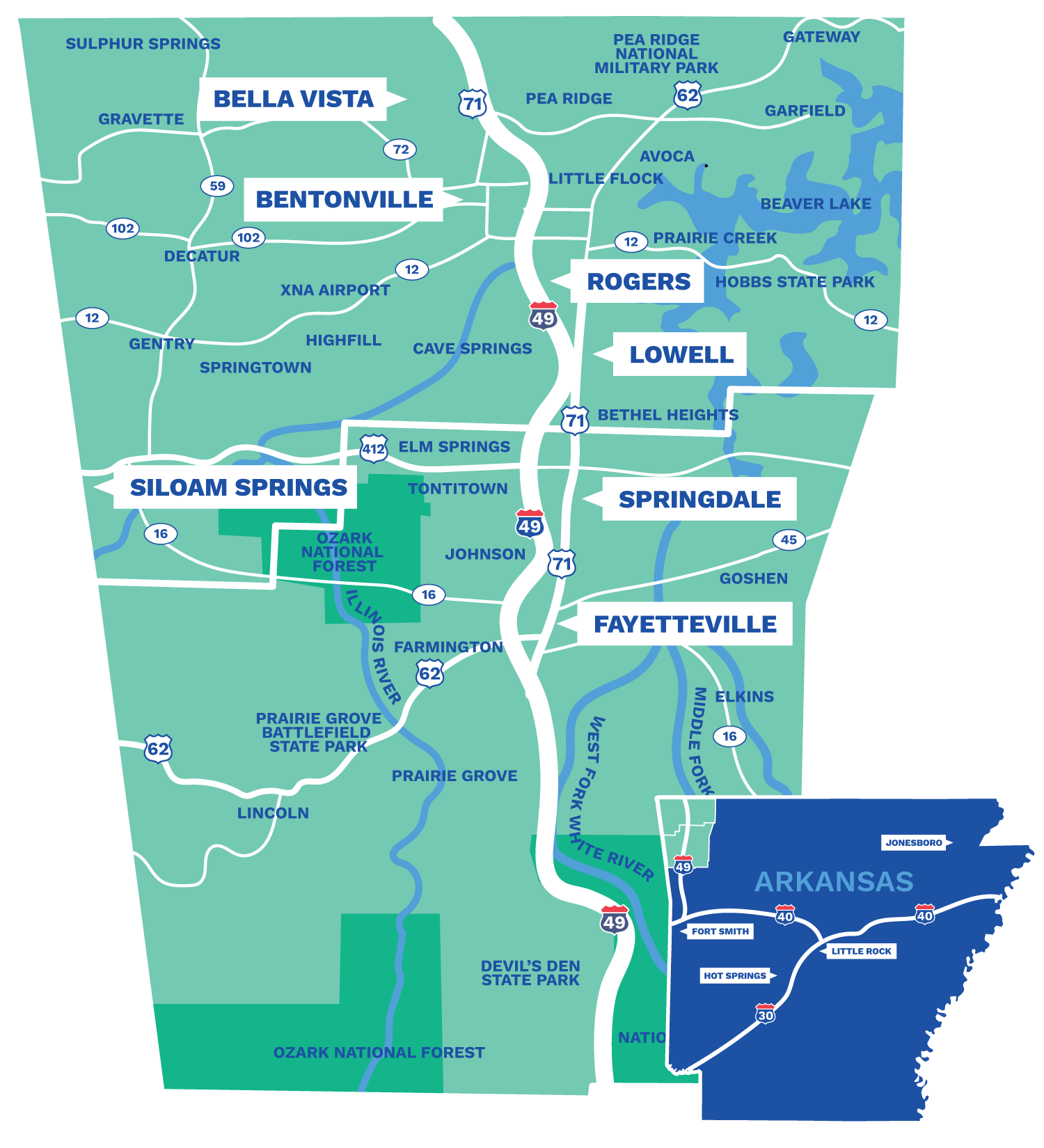
Bentonville Municipal Airport The Bentonville airport is also called Louis M. Thaden Field, an aviation pioneer. The airport’s 4,427-foot asphalt runway makes it an excellent option for general aviation and small-plane travel. Summit Aviation is the airport’s FBO.

Fayetteville Executive Airport The Fayetteville airport, also known as Drake Field, once served as the region’s commercial hub, but that changed with the opening of XNA in 1998. Now, the Fayetteville airport is among the nation’s premiere general aviation airports with quick access to the University of Arkansas campus. The airport is home to the Arkansas Air & Military Museum.

Rogers Municipal Airport Its 6,011-foot, lighted, paved runway make the Rogers airport ideal for people traveling on charter flights or their own plane to do business with Walmart and throughout Benton County. Because of its close access to Walmart Stores, it’s one of the busiest airports in the state with chartered and corporate planes arriving and departing all day long. Beaver Lake Aviation serves as its FBO.

Siloam Springs Municipal Airport Also known as Cecil Smith Field, the Siloam Springs airport provides the best access for people traveling to Siloam Springs, Gentry, Decatur and cities near the Oklahoma line. It has a paved 5,000-foot runway.

Springdale Municipal Airport Its 5,302-foot runway makes the Springdale airport an option for general aviation pilots. It’s well centered in Northwest Arkansas, providing quick access to Springdale but also Fayetteville, Lowell and Rogers. Summit Aviation serves as the airport’s FBO.

Rail Transportation

Arkansas and Missouri Railroad is a Class III railroad that operates between Monet, Mo., and Fort Smith, Ark. The Arkansas and Missouri Railroad Co. provides Northwest Arkansas with freight and occasional passenger line services and ties in with other major rail services. Approximately 3,000 loads move through the line each month on 150 miles of rail tracks.

The Kansas City Southern Railway Co., based in Kansas City, Mo., provides freight rail service to 10 states in Midwest, South and South Central U.S. and to Mexico. It’s major north-south line passes through the Benton County cities of Gentry Siloam Springs in Northwest Arkansas, providing service to companies in those communities.

Public Transportation

Ozark Regional Transit (ORT) provides bus service in four Northwest Arkansas counties, but the vast majority of its routes are in Benton and Washington counties. ORT provides fixed routes in larger Northwest Arkansas cities in Benton and Washington counties and on-demand services for its customers throughout the four counties.

Razorback Transit is the bus system for the University of Arkansas in Fayetteville, but its routes extend to destinations throughout the city. Those extended routes go to locations that include the Northwest Arkansas Mall, Walmart stores and to some residential areas where there are apartment complexes and large student populations. Rides are free to the general public.

NWA Trails The Razorback Regional Greenway provides a 37-mile bicycle / pedestrian route from Bella Vista to Fayetteville, connecting to over 200 miles of hard and soft surface city trail systems.

Water Transportation

McClellan-Kerr Arkansas River Navigation System is a 445-mile waterway used for commercial shipping on the Arkansas River to the Mississippi River and eventually to the Gulf of Mexico. A public shipping port is located 55 miles south of Fayetteville in Fort Smith, Ark. Shipping to the port can be accessed via I-49 or the Arkansas and Missouri Railroad line that provides a smooth transition for various modes of transportation and quick delivery.